Everest Base Camp with Gokyo Valley

Everest Base Camp with Gokyo Valley
Duration
18 Days
Trip Grade
Strenuous
Country
Nepal
Maximum Altitude
5,420 m.| 17,782 ft.
Group Size
1 to 15 People
Starts/Ends
Lukla - Lukla
Communication
Phone & WiFi
Activities
Trekking
Best Time
Autumn and Spring

A Himalayan journey through hidden lakes, sacred valleys, and mountain dreams. There are few places on Earth where every step feels like a pilgrimage and fewer still where mountains seem alive with stories. The Everest Cho La Pass & Gokyo Valley Trek is one such journey. It’s a path that traces the heartbeat of the Khumbu from prayer flags fluttering above stone houses to the glassy reflection of the mountains shimmering in the turquoise Gokyo Lakes.

This 17-day adventure takes you across one of Nepal’s most captivating trails. It is a perfect balance between challenge and beauty. You’ll walk from the bustle of Lukla into a land ruled by peaks and silence, climb to Gokyo Ri for the Himalaya’s finest panorama, cross the formidable Cho La Pass, and stand at the base of the world’s highest mountain.

It’s more than a trek. It is a slow unfolding of landscapes and spirit, a reminder that the Himalayas are not just mountains, but living memories carved in stone, ice, and faith.

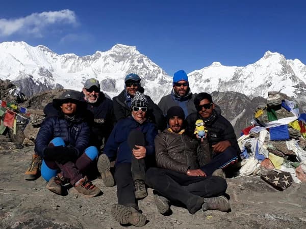
At Iconic Himalaya, our experienced guides ensure your comfort and safety every step of the way, turning this once-in-a-lifetime journey into a story you’ll proudly tell for years.

Ready to take on the challenge? Contact us anytime and start your ascent to the roof of the world.

Everest Cho La Pass & Gokyo Valley Trek Highlights

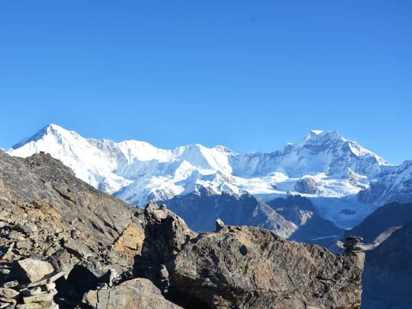
  • Cross the legendary Cho La Pass (5,420m), one of the most iconic high crossings in the Everest region.
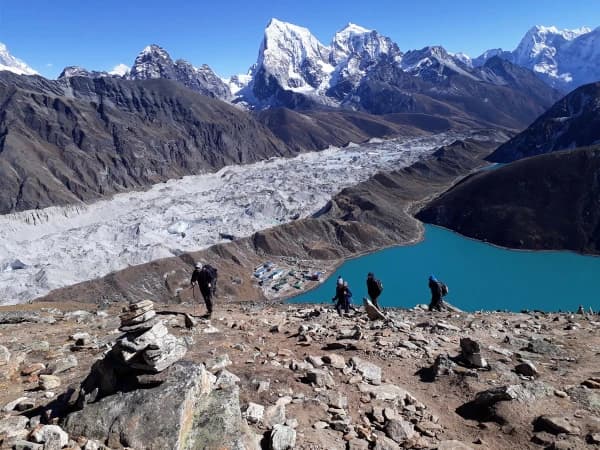
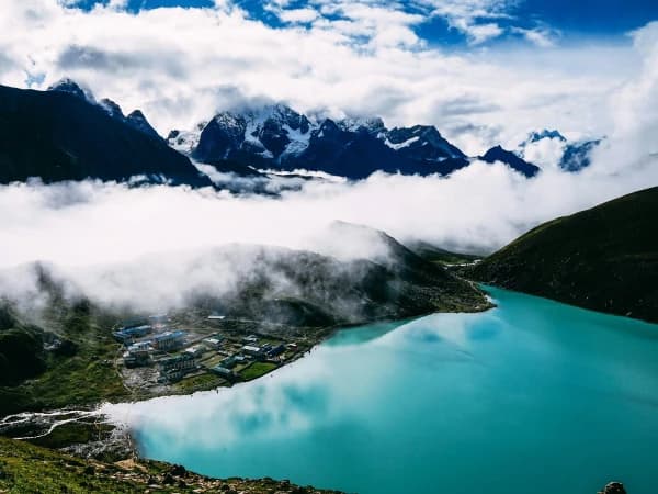
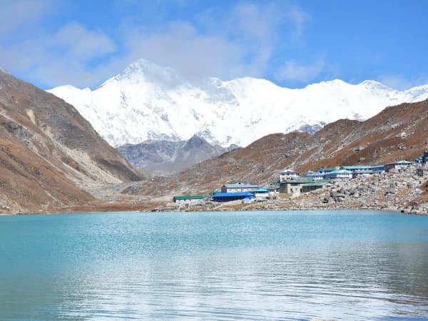
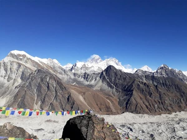
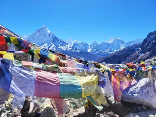
  • Explore the turquoise Gokyo Lakes, shimmering jewels of the high Himalaya.
  • Climb Gokyo Ri (5,360m) for one of the world’s greatest mountain views of Everest, Lhotse, Cho Oyu, Makalu, and more.
  • Stand at the legendary Everest Base Camp (5,364m), the heart of mountaineering dreams.
  • Watch the sun rise behind Everest from Kala Patthar (5,545m).
  • Immerse yourself in Sherpa culture, spirituality, and mountain hospitality.
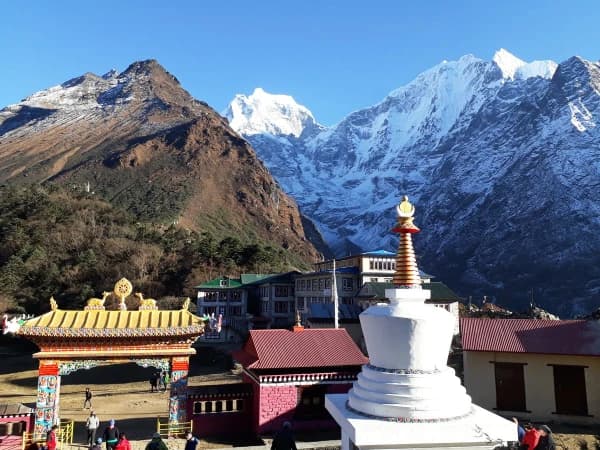
  • Visit Tengboche Monastery, home to ancient chants and sacred traditions.
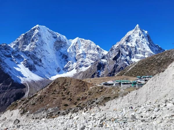
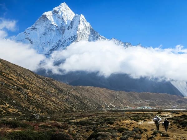
  • Walk beneath peaks like Ama Dablam, Thamserku, and Cholatse, each a work of nature’s artistry.
  • Experience the rich biodiversity of Sagarmatha National Park, a UNESCO World Heritage site.
  • Trek through rhododendron forests, glacier valleys, and timeless Himalayan villages.


Everest Base Camp with Gokyo Valley Itinerary

Note: During peak travel months such as April, May, October and November, direct flights from Kathmandu to Lukla are not available. Instead, you will have to opt from flying to Lukla from Manthali. Manthali is a pleasant 5–6-hour drive from Kathmandu.

Lukla - LuklaExpand all

The adventure begins with your arrival in Kathmandu, a city where history hums in every alley and the air carries the scent of incense and adventure. An Iconic Himalaya representative will greet you at the airport and escort you to your hotel. As you drive through the fabled streets of Kathmandu, you’ll feel the first spark of excitement for the journey ahead.

In the evening, you’ll meet your trek leader for a detailed briefing and enjoy a traditional Nepali dinner, a perfect introduction to Nepal’s warmth and hospitality.

Max Altitude: 1,455 m.|4,773 ft. Accommodation: Check in at Hotel ThamelMode of Travel: Pick up from the AirportDuration: 20 to 30 MinutesDistance: 6 Kilometers

Today, you discover the spiritual heart of Nepal. Wander through the serene courtyards of Bouddhanath Stupa, where monks spin prayer wheels and pigeons rise in clouds above the dome. Visit the sacred Pashupatinath Temple, where Hindu devotees offer prayers along the Bagmati River, and explore Kathmandu Durbar Square, an open-air museum of ancient palaces and temples.

Later, you’ll check your gear and prepare for the trek. By nightfall, the city’s hum fades to a quiet anticipation whilst the mountains await.

Max Altitude: 1,455 m.|4,773 ft. Meals: BreakfastAccommodation: Standard Hotel in ThamelMode of Travel: Car/Jeep/VanDuration: 6 to 7 Hours

The day begins before dawn with a short, unforgettable flight to Lukla (2,860m), the gateway to Everest. The small aircraft weaves between snow-capped peaks before landing on a mountain runway. It is definitely a thrill that marks the true beginning of your trek.

From Lukla, the trail descends gently through pine forests and stone villages. Children wave from doorways; mani stones and prayer wheels line the path – a perfect glimpse of the journey that lies ahead. You’ll follow the Dudh Koshi River, crossing a suspension bridge that sways above turquoise waters, before reaching Phakding (2,610m), a peaceful riverside village surrounded by the hum of nature.

Max Altitude: 2,640 m.| Meals: Breakfast, Lunch and DinnerAccommodation: Guest house or LodgeMode of Travel: Drive/Flight and WalkingDuration: Depends on weather and road condition

The trail today is long but spectacular. It winds through the Sagarmatha National Park, passing through rhododendron forests and small settlements. You’ll cross several suspension bridges, one of them the famous Hillary Bridge, draped in prayer flags that dance against the wind.

The final ascent to Namche Bazaar (3,440m) is steep and demanding, but just before you reach the top, you’ll catch your first glimpse of Mount Everest. Namche appears like a colorful amphitheater carved into the mountainside. It is a lively Sherpa town with bakeries, gear shops, and breathtaking views.

Max Altitude: 3,440 m.|11,286 ft. Meals: Breakfast, Lunch and DinnerAccommodation: Guest house or LodgeMode of Travel: WalkingDuration: 6 to 7 HoursDistance: 11 Kilometers

Rest and exploration blend perfectly today, preparing you to acclimatise before you begin your journey to higher regions. After breakfast, hike to the Everest View Hotel (3,880m), where the panorama of Everest, Lhotse, and the graceful Ama Dablam unfolds like a painting.

On your way down, visit Khumjung Village and its monastery, home to the mysterious yeti scalp; a relic of Sherpa folklore. You can stop by the Edmund Hillary School, built as a tribute to the friendship between Sherpas and mountaineers. The afternoon is yours to enjoy, sip coffee in a mountain cafƩ, visit the Sherpa Museum, or simply gaze at the peaks that tower above the clouds.

Max Altitude: 3,880 m.|12,729 ft. and back to Namche Meals: Breakfast, Lunch and DinnerAccommodation: Guest house or LodgeMode of Travel: WalkingDuration: 4 HoursDistance: 4.5 Kilometers

Leaving Namche, the trail climbs gently out of Namche, with magnificent views of Kangtega and Ama Dablam glowing against the blue sky. You’ll pass through rhododendron and juniper forests, eventually reaching Mong La Pass (3,975m), a ridge-top village with a stupa and a panorama that stops you in your tracks.

A steep descent brings you to Phortse Thanga (3,680m), a quiet settlement beside the Dudh Koshi River. Here, the air feels crisper, and the sounds of rushing water and prayer flags in the wind lull we will continues to the quiet village of Dole. The air thins and the vegetation changes; terraced fields give way to yak pastures and wind-toughened stone walls. Dole’s teahouses are modest but warm, and the evening light here — long and cool — perfectly frames the peaks beyond.

Max Altitude: 4,038 m.|13,248 ft. Meals: Breakfast, Lunch and DinnerAccommodation: Guest house or LodgeMode of Travel: WakilngDuration: 6 to 7 HoursDistance: 12 Kilometers

The landscape now begins to change — trees thin out, and the world becomes one of stone, sky, and light. You’ll ascend gradually through the pastures of  Luza, where yaks graze under snowy ridges.

Arriving at Machhermo (4,470m), a compact settlement with panoramic views across the valley. The terrain is open, and the path passes summer grazing areas where yaks and horses bed down. Machhermo, you find yourself in a serene valley surrounded by towering peaks. It has a calm, unhurried rhythm and is an ideal place to rest. Locals may share the tale of the ā€œyeti attackā€ that once occurred here, a piece of local legend that adds mystery to the high Himalaya. Before moving higher into the Gokyo basin, spend the evening watching the sun fade behind Kyajo Ri, painting the village in gold. 

Max Altitude: 4,470 m.|14,665 ft. Meals: Breakfast, Lunch and DinnerAccommodation: Guest house or LodgeMode of Travel: WalkingDuration: 3 to 4 HoursDistance: 7 Kilometers

Today’s trek feels like stepping into another world. The trail follows the river upstream as the valley widens into open glacial terrain. Soon, the first Gokyo Lake appears turquoise and still, its surface reflecting the surrounding peaks like glass.

As you move higher, the second and third lakes appear, each more breathtaking than the last. The third, Dudh Pokhari cradles Gokyo Village (4,790m), your home for the night. The place feels otherworldly silent, pure, and utterly magnificent, where mountains meet water in perfect harmony.

Max Altitude: 4,790 m.|15,715 ft. Meals: Breakfast, Lunch and DinnerAccommodation: Guest house or LodgeMode of Travel: WalkingDuration: 4 to 5 HoursDistance: 7.5 Kilometers

Before dawn, you’ll begin the ascent of Gokyo Ri (5,360m). The climb is steep but every step brings expanding horizons until suddenly, you stand atop the summit, and the view steals your breath: Everest, Lhotse, Cho Oyu, and Makalu, the giants of the Earth, lined up in a single, unforgettable panorama.

After descending, spend the day exploring the Gokyo Lakes sacred to both Hindus and Buddhists. You may also visit the Ngozumpa Glacier, the longest glacier in Nepal, an ancient river of ice that stretches far into the distance. Evening descends quietly over the lakes, their waters glowing in the fading light.

Max Altitude: 5,357 m.|17,575 ft. descend to 4,790 m. Meals: Breakfast, Lunch and DinnerAccommodation: Guest house or LodgeMode of Travel: WalkingDuration: 3 to 4 HoursDistance: 4 Kilometers

Today’s trail leads you across the expanse of the Ngozumpa Glacier. The path undulates through a maze of rock and ice, surrounded by silence and grandeur. After a few hours, you’ll reach Thagnak/Dragnag (4,700m), a small settlement tucked beneath the cliffs. It’s a place of preparation — tomorrow, you’ll cross one of the Himalaya’s great passes.

Max Altitude: 4,700 m.|15,419 ft. Meals: Breakfast, Lodge and DinnerAccommodation: Guest house or LodgeMode of Travel: WalkingDuration: 2 to 3 HoursDistance: 5 Kilometers

Before sunrise, you set out under starlight. The air is cold and thin, and the crunch of ice beneath your boots echoes in the stillness. The climb to Cho La Pass (5,420m) is steep and demanding — a true test of endurance.

But when you reach the top, the world opens wide: endless ridgelines, frozen lakes, and snow-dusted peaks stretching beyond the horizon. The descent to Dzongla (4,830m) is steep yet beautiful, winding past glacial moraines and prayer flags fluttering bravely in the wind.

This is the heart of adventure where exhaustion and awe merge into a single emotion.

Max Altitude: 5,420 m.|17,782 ft. descend to 4,830 m.|15,846 ft. Meals: Breakfast, Lodge and DinnerAccommodation: Guest house or LodgeMode of Travel: WalkingDuration: 7 to 8 HoursDistance: 12 Kilometers

Today’s walk feels calm and reflective after the triumph of Cho La. The path follows a contour above the valley with spectacular views of Cholatse and Ama Dablam. Within a few hours, you arrive at Lobuche (4,910m), a high-altitude village where trekkers and mountaineers gather at the last stop before Base Camp.

The air is thinner, the stars brighter. You feel close to the sky itself.

Max Altitude: 4,940 m.|16,207 ft. Meals: Breakfast, Lunch and DinnerAccommodation: Guest house or LodgeMode of Travel: WalkingDuration: 3 to 4 HoursDistance: 8 Kilometers

The trail follows the Khumbu Glacier, a landscape of rock, ice, and silence. You’ll reach Gorak Shep (5,170m), the final settlement on the route, and continue toward Everest Base Camp (5,364m).

When you finally arrive, the feeling is indescribable. You stand on the ground where legends begin where climbers dream, and mountains decide. Prayer flags flutter, glaciers crack, and the wind carries a thousand stories. You’ve reached the foot of Everest.

Return to Gorak Shep for the night, heart full and soul humbled.

Max Altitude: 5,364 m.|17,598 ft. back to 5,140 m.|16,863 ft. Meals: Breakfast, Lunch and DinnerAccommodation: Guest house or LodgeMode of Travel: WalkingDuration: 6 to 7 HoursDistance: 11 Kilometers

An early start takes you to the summit of Kala Patthar (5,545m), a rocky ridge known for the most iconic view of Everest. As dawn breaks, the first rays of sunlight touch the summit, turning it into gold.

No photograph can capture the feeling — the silence, the wind, the realisation of where you stand. After descending, you’ll trek down through Lobuche to Pheriche (4,240m), a tranquil valley where warmth returns to the air.

Max Altitude: 5,555 m.|18,225 ft descend to 4,371 m.|14,340 ft. Meals: Breakfast, Lunch and DinnerAccommodation: Guest house or LodgeMode of Travel: WalkingDuration: 7 to 8 HoursDistance: 13 Kilometers

The trail descends through familiar landscapes past Pangboche and Tengboche, whose monastery chants echo softly through the forest. You’ll stop to rest among rhododendron trees and follow the winding path back to Namche Bazaar (3,440m). 

Hot showers, bakeries, and comfort awaits and with them, a sense of homecoming.

Max Altitude: 3,440 m.|11,286 ft. Meals: Breakfast, Lunch and DinnerAccommodation: Guest house or LodgeMode of Travel: WalkingDuration: 6 to 7 HoursDistance: 18 Kilometers

Your final day on the trail is a walk of gratitude. The path descends gently along the Dudh Koshi River, through pine forests and stone villages that now feel like old friends.

As you reach Lukla (2,860m), you’ll feel the weight of the journey behind you — the high passes crossed, the lakes reflected, the mountains remembered. Celebrate the end of your trek with your team Sherpas, guides, and new friends who’ve shared the adventure of a lifetime.

Max Altitude: 2,840 m.|9,317 ft. Meals: Breakfast, Lunch and DinnerAccommodation: Guest house or LodgeMode of Travel: WalkingDuration: 7 to 8Distance: 18 Kilometers

The short flight from Lukla to Kathmandu feels like a dream, the Himalayas fading into clouds, the hum of the city returning. You’ll be transferred to your hotel, where a hot shower and soft bed await.

In the evening, gather one last time for a farewell dinner. Toast to the memories you’ve made of lakes that mirror the sky, trails that test your limits, and mountains that will forever call you back.

As the Sherpas say, ā€œThe higher you climb, the closer you come to the gods.ā€
With the completion of this trek, you will have touched something vast — a piece of the Himalaya that will stay with you, quietly, forever.

Max Altitude: 1,455 m.|4,773 ft. Meals: Breakfast and LunchAccommodation: Standard Hotel in ThamelMode of Travel: Flight and DriveDuration: 30 Minutes Flight

After a leisurely morning, transfer to the airport for your onward journey. Take with you memories of adventure, breathtaking landscapes, and the intimate moments shared in the heart of the Himalayas.

Max Altitude: 1,455 m.|4,773 ft. Meals: BreakfastAccommodation: Check out in HotelMode of Travel: Drop to the AirportDuration: 20 to 30 MinutesDistance: 6 Kilometers
Unable to locate what are you seeking?Download brochure or customize your trip.
Customize Trip
Cost Details
Includes
  • In-country airport pickup & drop in a private vehicle.
  • Standard hotel accommodation (with breakfast) in Kathmandu.
  • Domestic flights (Kathmandu–Lukla–Kathmandu) including domestic airport taxes.
  • Professional, government-licensed English-speaking guide; experienced porters to carry luggage (approx 25 kg per porter; 1 porter per 2 trekkers).
  • All meals during the trek (breakfast, lunch & dinner) in tea houses.
  • Best available accommodation in tea houses during the trek.
  • Staff salary, insurance for staff, food and accommodation for crew.
  • All necessary permits: Sagarmatha National Park Permit, Khumbu Pasanglhamu Rural Municipality permit.
  • Water purification (tablets or filters) for safe drinking water.
  • First aid kit carried by the guide.
  • Emergency rescue assistance coordination.
  • All  government local taxes/VAT and office expenses
  • Sleeping bag, down jackets and a duffle bag- if necessary( return after trek).
  • Trip completion certificate and a trek route map.
Excludes
  • Nepal entry visa fee (obtainable on arrival or online).
  • Travel insurance (compulsory; must cover high-altitude rescue & helicopter evacuation).
  • Meals in Kathmandu beyond those included during the trek and all beverages (hot drinks, bottled water, and alcohol).
  • Personal trekking equipment (unless rented), laundry, phone calls, and hot shower or Wi-Fi charges in teahouses.
  • International airfare to/from Nepal.
  • Excess baggage charges on domestic flights.
  • Extra nights in Kathmandu for early arrival, late departure, or emergency/voluntary itinerary changes.
  • Optional trips and sightseeing if extended.
  • Tips/gratuities for guides and porters.
  • Any service not listed under ā€œIncludes.ā€
Dates & Availability

We run fixed-departure and private group treks throughout the main seasons. Customize departure dates to fit your schedule — families, solo trekkers, and private groups are welcome. Reserve early for autumn and spring seasons as spaces fill quickly.

Note:

  • The itinerary may change due to weather, flight cancellations, or health reasons. A buffer day is advised for flight delays to/from Lukla.
  • For trip confirmation, a deposit (typically 25% of total) is required; balance due per operator policy.
Everest Base Camp with Gokyo Valley Equipments

Equipment and accessories are essential for comfort, safety and success on high-altitude treks. Below is a detailed packing guide adapted for Cho La & Gokyo.

Equipment and Accessories packing list

Bag & Packs

  • Main backpack: 40–65 L capacity (comfortable hip belt, ventilated back).
  • Daypack: 20–30 L for daily essentials and valuables (water, camera, layers).
  • Duffel bag: for porter to carry the main luggage. (Provided by Iconic Himalaya if necessary)

Footwear

  • Sturdy, waterproof trekking boots with ankle support and crampon compatibility.
  • Comfortable camp shoes or sandals for evenings.
  • Spare trainers or sandals for village use.

Clothing

  • Warm down jacket (heavy) and lightweight insulated jacket for layering.
  • Fleece or mid-layers (2).
  • Waterproof, breathable shell jacket and pants.
  • Thermal base layers (top & bottom).
  • Quick-dry trekking shirts and long sleeve layers.
  • Trekking pants and a spare pair.
  • Warm hat/beanie, sun hat, gloves (liner and insulated), warm socks (wool).
  • Gaiters (helpful for snow or mud).

Sleeping & Bedding

  • Sleeping bag rated to at least -10 °C (ideally -15 °C for comfort).
  • Lightweight liner (optional but increases hygiene).

Gadgets & Accessories

  • Sunglasses (UV protected) and sunscreen (high SPF).
  • Headlamp with spare batteries.
  • Trekking poles (recommended).
  • Water bottles (2 Ɨ 1 L) and/or hydration bladder; water purification tablets.
  • Power bank and spare camera batteries (limited charging in tea houses).
  • Personal toilet kit, quick-dry towel, toilet paper.
  • Basic repair kit (needle/thread, duct tape), zip ties, and plastic bags for waterproofing.
  • Compass & map (guide will carry detailed maps).

Medical & First Aid

  • Personal prescription medicines and a small personal first aid kit.
  • Diamox (acetazolamide) if advised by your physician for acclimatization.
  • Pain relievers, antidiarrheal, rehydration salts, antiseptic wipes, blister plasters.

Women-Specific
For women trekkers, a few extra essentials can make the journey more comfortable and empowering. Carry trusted feminine hygiene products, moisturizer, and lip balm with SPF, along with wet wipes for long trekking days. A light shawl or scarf is useful for monastery visits or traditional households. Many teahouses are run by Sherpa women, creating a welcoming environment, and our guides ensure safety and comfort for female travelers. Trekking in the Himalaya as a woman is not just about the journey, but about discovering strength, independence, and community on the trail.

Prescription Medicine and First Aid
Carry regular prescriptions for the entire trip. Our guides carry an extended first aid kit; however, personal medicines for chronic conditions are the traveler’s responsibility.

Essential Information

Everest Cho La Pass & Gokyo Valley Trek Difficulty

This is a challenging trek, best suited for those who are fit, determined, and eager for adventure. Over 17 days, you’ll walk an average of 5–7 hours a day, sometimes on steep, rocky trails and occasionally over snow or ice, especially near the Cho La Pass. Crossing the pass itself (5,420m) can be physically demanding and requires careful footing but your guides will be with you every step of the way.

No technical climbing experience is needed, but good physical conditioning and a spirit of perseverance are essential. With proper acclimatization and pacing, most trekkers complete the journey safely and joyfully.

Altitude Sickness & Remedies

High altitude is part of what makes this journey both thrilling and humbling. The itinerary is carefully designed to allow gradual acclimatization, with rest days in Namche Bazaar and Dingboche to let your body adjust.

Symptoms like mild headaches, shortness of breath, or fatigue are common but they usually subside as you ascend slowly. Your guides are trained in altitude management, and you’ll be monitored closely throughout the trek. Staying hydrated, eating well, and maintaining a steady pace are key to staying healthy in the high Himalayas. Few measures to remember are listed below.

  • Hydrate liberally (3–4 L/day).
  • Climb slowly and obey rest/acclimatization days.
  • Inform the guide immediately of symptoms.
  • Medical option: Diamox (acetazolamide) under doctor’s advice.
  • Descend promptly if symptoms worsen (HAPE/HACE are medical emergencies).

Travel Insurance

Comprehensive travel insurance that covers emergency helicopter evacuation and high-altitude rescue is mandatory. Confirm policies cover altitudes up to 6,000 m and include trip cancellation for weather or medical emergencies.

Training for the Trek

Prepare with cardiovascular training (walking, hiking with a weighted pack, stair climbing) for 6–8 weeks prior. Include multi-hour hikes with elevation gain to build endurance. Strength training for legs and core helps with long descents.

Best Time & Weather Notes

The Everest Cho La Pass & Gokyo Valley Trek can be done almost any time of year, but the mountains reveal their best face in spring (March–May) and autumn (September–November).
In spring, the trails bloom with rhododendrons, the air feels crisp, and the views are endlessly clear. The days are warm, nights still cold, and the lakes shimmer under deep blue skies.
Autumn brings golden light, calm weather, and the Himalayas at their most photogenic, snow peaks glowing white against cobalt skies.
Winter (December–February) can be magical too, with fewer trekkers and crystal-clear mornings, though the Cho La Pass may be blocked by snow. Monsoon season (June–August) paints the valleys green, but rain and clouds often obscure the views.

For most, the best months are late March to early June and mid-September to late November, when the mountains stand proudly under the clearest skies.

Food & Accommodation on the Trek

Throughout the trek, you’ll stay in cozy teahouses, family-run mountain lodges that offer a blend of comfort and character. Rooms are simple but warm, often built of stone and wood, with twin beds and thick blankets. Shared bathrooms are the norm, and hot showers are available at most stops (for a small fee).

Meals are prepared fresh and served with care. A hearty local dal bhat (rice and lentil soup), noodles, soups, momo, and pancakes. In higher villages, you might enjoy apple pie from a Sherpa bakery or hot chocolate with a mountain view.

All meals during the trek (breakfast, lunch, and dinner) are included. In Kathmandu, you’ll stay in a comfortable 3-star hotel with breakfast included.

Nutshell

  • Max Altitude: 5,420 m (Cho La Pass) & 5,545 m (Kala Patthar viewpoint).
  • Duration: 17 days Kathmandu–Kathmandu.
  • Terrain: Forest trails, moraines, glacier crossings, and rocky passes.
  • Average daily walking: 5–7 hours.
  • Accommodation: Tea houses and mountain lodges; hotels in Kathmandu.
  • Food: Local Nepali, Tibetan and continental options available.
  • Permits: Sagarmatha National Park Permit; local municipality permit.
  • Emergency: Helicopter evacuation available (cost borne by your insurance).


Everest Base Camp with Gokyo Valley FAQs

Most teahouses offer solar electricity for charging phones and cameras (for a small fee).
Wi-Fi is available in many lodges, though the signal can be slow or intermittent at higher altitudes.
We suggest carrying a power bank and enjoying a digital detox, the views here are far better than any screen.

The trek is more than just mountain views, it’s the sound of yak bells in the thin air, the laughter of Sherpa children, the reflection of Cho Oyu on a glassy Gokyo Lake, and the hush of prayer flags fluttering over a high pass. You’ll return with tired legs, a full heart, and a sense of wonder that will stay with you for life.

Yes, it’s best to carry Nepali rupees for small expenses such as snacks, Wi-Fi, showers, or souvenirs.
There are ATMs in Namche Bazaar, but not beyond. Plan to withdraw cash in Kathmandu before departure.

We are committed to sustainable tourism, respecting local communities, minimizing plastic waste, and ensuring fair treatment for guides and porters. We encourage trekkers to use refillable water bottles, avoid single-use plastics, and support local teahouses along the trail.
Every trek you take with us contributes to preserving the fragile beauty of the Khumbu region.

Absolutely.
We welcome solo trekkers, couples, and small groups. Solo travelers can join a fixed departure group for company and safety, or request a private guided trek for more flexibility. Either way, you’ll be well looked after from arrival to departure.

Drink plenty of water (at least 3 liters a day), avoid alcohol and smoking, and eat warm, nourishing meals. Carry rehydration salts, sunscreen, and lip balm. Rest when needed, walk at your own pace, and listen to your body, it’s your best guide in the mountains.

The Himalayas are unpredictable, and heavy snowfall or strong winds can temporarily close the pass. If that happens, your guide will choose the safest alternate route, either returning via Gokyo Valley or adjusting the schedule until it clears. Flexibility is key in mountain travel, and our team always prioritizes safety over itinerary.

You must have travel insurance that covers high-altitude trekking (up to 6,000m) and emergency helicopter evacuation. Please share your policy details with us before the trek. If you need guidance choosing a plan, our team can recommend reliable providers.

Yes.
We can tailor the itinerary to suit your interests, time frame, or fitness level. Some trekkers prefer to add extra nights for acclimatization, or finish with a helicopter flight from Gokyo or Gorakshep for a grand finale. Just let us know your preferences, we’ll design a route that fits your goals perfectly.

Safety is always our top priority. Our guides carry first aid kits, pulse oximeters, and have access to emergency helicopter evacuation if needed. We also stay updated on weather and trail conditions, especially before crossing the Cho La Pass. With proper acclimatization, a reliable guide, and cautious pacing, this trek is considered safe and achievable for most trekkers.

It’s considered a challenging trek, designed for those with a good level of fitness and a sense of adventure. You’ll walk an average of 5–7 hours a day over varied terrain — rocky paths, suspension bridges, glacier crossings, and steep ascents. The crossing of Cho La Pass (5,420m) is the most demanding day, requiring steady footing and stamina, but your guide will pace you well and ensure you’re safe and supported. No technical climbing skills are needed just preparation, determination, and a love for the mountains.

Layering is key in the mountains. Pack lightweight, moisture-wicking base layers, a fleece jacket, a down jacket, waterproof shells, warm gloves, hat, trekking boots, and sunglasses. A four-season sleeping bag, trekking poles, water purification tablets, and a headlamp are also highly recommended.
We’ll provide a detailed packing list once you book your trek — and we can help you rent or buy any missing gear in Kathmandu.

Your journey begins with a short, scenic flight to Lukla often described as one of the most thrilling airstrips in the world. During peak trekking months, flights may operate via Manthali Airport (Ramechhap) instead of Kathmandu, requiring an early morning drive (5–6 hours).
Our team manages all logistics to make this transition smooth and timely.

For this trek, you’ll need:

  • Sagarmatha National Park Entry Permit
  • Khumbu Pasang Lhamu Rural Municipality Permit

We take care of all permits and paperwork for you before your trek begins.

Yes and it’s highly recommended. Our licensed, English-speaking guides are experienced in this route, trained in first aid and altitude management, and will share stories and insights that enrich your journey. Porters will carry your main luggage (up to 15 kg per person), so you only need to walk with a light daypack. At Iconic Himalaya, we ensure all guides and porters are fairly paid, insured, and equipped with proper gear.

You’ll stay in local teahouses charming family-run lodges offering a cozy room, hearty meals, and genuine hospitality. Rooms are simple with twin beds and shared bathrooms. Some places offer hot showers (for a small charge) and Wi-Fi access. Meals are fresh and plentiful — dal bhat, soups, pasta, momos, porridge, and occasional treats like apple pie or pancakes.
You’ll also stay in a comfortable 3-star hotel in Kathmandu before and after the trek.

The two best trekking seasons are:

  • Spring (March–May): When rhododendrons bloom and the valleys glow with color.
  • Autumn (September–November): When skies are clearest and the views are most dramatic. Winter (December–February) can offer solitude and crisp beauty but the Cho La Pass may be snowed over, requiring flexibility. Monsoon (June–August) brings rain and leeches in lower regions, but the landscapes are lush and green.

The highest point of the trek is Cho La Pass at 5,420 meters. Altitude affects everyone differently, and symptoms like mild headaches or fatigue are common. Our itinerary includes acclimatization days in Namche Bazaar and Dingboche to allow your body to adapt gradually. Your guide will monitor your health throughout the trek, and if needed, we adjust the pace or route for your safety.

Not necessarily. Many first-time trekkers complete this route successfully. However, having some hiking experience and being in good physical shape will make the journey more enjoyable. We recommend training at least 6–8 weeks in advance with regular hikes, cardio exercises, and strength training for your legs and core.

Remember, it’s not a race, steady pacing, proper acclimatization, and positive spirit are what truly matter.

While both routes share the same starting trail up to Namche Bazaar, the Cho La Pass & Gokyo Valley trek takes you off the beaten path into the turquoise world of Gokyo Lakes six sacred glacial lakes surrounded by towering peaks. You’ll also climb Gokyo Ri (5,357m) for one of the most stunning Himalayan panoramas Everest, Lhotse, Makalu, and Cho Oyu all visible in a single sweep. Crossing the Cho La Pass connects you to the Everest Base Camp route, giving you the best of both worlds fewer crowds, richer landscapes, and a true sense of adventure.

Speak to an Expert+977 9851130654
Need Help? Call Us+977 9851130654